Difference between revisions of "Barkip"
(Created page with "{{Infobox UK place | official_name = Barkip | gaelic_name= | scots_name= | local_name= The Den | country= Scotland | population = | population_ref = | population_densi...") |
|||
| Line 1: | Line 1: | ||
| − | {{ | + | {{Place |
| − | | | + | | name = Barkip |
| − | | | + | | gaelic = |
| − | + | | country = Scotland | |
| − | + | | county = North Ayrshire | |
| − | | country= Scotland | + | {{#display_map: 55.64464220631475,-4.810981750488281|mappingservice=leaflet|zoom=11}} |
| − | | | ||
| − | |||
| − | |||
| − | |||
| − | |||
| − | |||
| − | |||
| − | |||
| − | |||
| − | |||
| − | |||
| − | |||
| − | |||
| − | |||
| − | |||
| − | |||
| − | |||
| − | |||
}} | }} | ||
| + | {{DabPlace|Hamlet|North Ayrshire|}} | ||
| − | '''Barkip''' | + | '''Barkip''' is a hamlet in [[North Ayrshire]], Scotland about three miles south-west of [[Beith]] on the A737 road to [[Dalry]]. The earliest recorded name is 'Blairkip'. In the Gaelic language, the name Barkip comes from ''bar'' ("top"), and ''kip'' ("a rank of soldiers"). It is not clear when or why the name 'The Den' started to be used although it appears in the local press as both in 1898, however in Scots as in old English one meaning is 'A hollow between hills,' which is certainly an accurate description of the geography of the area that Barkip lies in. |
== History == | == History == | ||
| − | Pont's survey of the early 1600s records a 'Bar-Kyipe' lying in the | + | Pont's survey of the early 1600s records a 'Bar-Kyipe' lying in the The Barony of Kersland and Dobie records that Barkip formed part of the estate of Roughwood in 1874, belonging to William Ralston-Patrick. In the 19th century the population was 995. |
| − | + | Willem Blaeu's map of circa 1604 records a 'Barkirsh' settlement, probably today's nearby 'Barcosh'. William Roy's map of 1747 records the settlements of Mallside and a Blairkip. In the year 1726, William Park and John his son granted to John Hamilton an heritable bond, in common form, for 3000 merks, over the lands of Barkip. | |
| − | In March 1898, a local paper reported a complaint that a dance had taken place at the Kersland Barony school and Kirk that had lasted into the small hours. Members of the church congregation threatened to leave through their indignation at the building being used for such frivolous activities. | + | In March 1898, a local paper reported a complaint that a dance had taken place at the Kersland Barony school and Kirk that had lasted into the small hours. Members of the church congregation threatened to leave through their indignation at the building being used for such frivolous activities. That same month, students at the Kersland Barony evening continuation classes presented their teachers, Mr Deans and Miss Lorraine, with gifts of appreciation. The Rev A Leslie chaired the event and Miss Lorraine was presented with an inscribed umbrella, whilst Mr Deans had a silver walking stick as his recognition. Songs, recitations, flute, and violin entertainments were part of the night's proceedings. |
| − | An 1876 publication, ''Catalogue of the western Scottish fossils'', documented finds in Barkip's coal and ironstone pits and sandstone quarries, including that of '' | + | An 1876 publication, ''Catalogue of the western Scottish fossils'', documented finds in Barkip's coal and ironstone pits and sandstone quarries, including that of ''Rhizodus'', ''Gyracanthus'', and ''Cladodus''. The village had a certain reputation for problems linked to illicit drinking. It was reported in 1898 that Sunday drinking resulted in men lying around drunk in the Maulside plantations and some were playing cards. |
==Geography== | ==Geography== | ||
| − | Barkip is located in southwest Scotland in [[North Ayrshire]] and lies about three miles south-west of [[Beith]]. Geologically, Barkip consists of mainly sandstone. | + | Barkip is located in southwest Scotland in [[North Ayrshire]] and lies about three miles south-west of [[Beith]]. Geologically, Barkip consists of mainly sandstone. Two areas of the rare habitat type known as 'raised bogs' are located at Barkip and Little Barkip. These were surveyed for the Ayrshire Biodiversity Action Plan (ABAP) by the NAC Ranger Service in 2010. Raised bogs develop over centuries from open lake, to marsh, and eventually bog that continues to form peat, and over time a shallow dome of bog peat develops: a raised bog. The dome is typically a few metres high in the centre, and is often surrounded by strips of fen. The Barkip sites have the typical bog plants, such as sundew, cotton grass, deer grass, and sphagnum mosses. [[Highfield]] is the next village along on the A737 towards Dalry. |
==Notable landmarks== | ==Notable landmarks== | ||
| − | The old Kersland Barony school had a church-like belfry over the front gale and was used as church on Sundays. | + | The old Kersland Barony school had a church-like belfry over the front gale and was used as church on Sundays. The Rev. Robert Stevenson D.D., minister of Dalry 1844-1890, caused to be erected the Kersland Barony Chapel and school. He bequeathed £2,500 for Kersland Barony chapel. In 1901 the Herald recorded that ''"The scholars of Kersland Barony School, Dalry, under the direction of Mr Deans, headmaster, and Mr Gibson, drill instructor, gave a most enjoyable entertainment on two evenings last week".'' |
| − | |||
| − | |||
| − | Maulside House, previously Maulhead, | + | The village at one time had a police station, two public houses, a cinema, and a bowling green. {{stnlnk|Brackenhills}} was located midway between Beith and Barkip on the [[Lanarkshire and Ayrshire Railway]]'s branch to {{Stnlnk|Kilbirnie South}}. [[Defence Munitions Beith]] (DM Beith) is located nearby. |
| + | |||
| + | The hamlet contains several cottages including Auchengree Cottage, Rosehill Cottage and Muirhouse Cottage. A smithy was located at the Crossroads near where Graze Restaurant now stands (2012). A second smithy was situated on the crossroads near West Muirhouse Farm and Highden House. This smithy, now demolished, was unusual in that it had stables associated with it; these survive as a private dwelling. An explosives magazine was located at the site of the old Low Well opposite West Muirhouse Farm. Davidshill House was once an isolation hospital, locally known as the 'Sick House'. | ||
| + | |||
| + | Maulside House, previously Maulhead, was built on the site of an earlier mansion held by the Russells. The present house was built for Andrew Mitchell, Writer to the signet, in the 1830s. he improved his estate lands, draining the mosses, turning them into productive fields. Maulside Mains is a 'B' Listed, early 19th century, rectangular-plan stable block with a 'U' shaped courtyard beyond. | ||
[[File:Barkip Anaerobic-Digester Biomass powerplant.JPG|thumb|200px|The Barkip Biogas Plant.]] | [[File:Barkip Anaerobic-Digester Biomass powerplant.JPG|thumb|200px|The Barkip Biogas Plant.]] | ||
| − | Located a short distance from the settlement is the Barkip Biogas power plant, the largest anaerobic digestion power plant in Scotland when completed in June 2011. It uses [[anaerobic digestion]] to produce electricity from leftover food and other organic materials. The only by-product is a high nutrient fertiliser that can be returned to the land to help produce more food. The Barkip Biogas facility was built for the utility provider Scottish & Southern Energy Generation Ltd. It is operated by | + | Located a short distance from the settlement is the Barkip Biogas power plant, the largest anaerobic digestion power plant in Scotland when completed in June 2011. It uses [[anaerobic digestion]] to produce electricity from leftover food and other organic materials. The only by-product is a high nutrient fertiliser that can be returned to the land to help produce more food. The Barkip Biogas facility was built for the utility provider Scottish & Southern Energy Generation Ltd. It is operated by Zebec Energy, a West of Scotland company. The facility has the capacity to process up to 75,000 tonnes-a-year of residual waste and has been designed to produce up to 2.5 megawatts (MW) of renewable electricity. The plant was officially opened by the [[Duke of Rothesay]] (Prince Charles) in May 2012. |
==Notable people== | ==Notable people== | ||
| − | * Jean Gilbert, born at Barkip Farm in 1942 near The Den. North Ayrshire Council's 'Citizen of the Year' for 2012. | + | * Jean Gilbert, born at Barkip Farm in 1942 near The Den. North Ayrshire Council's 'Citizen of the Year' for 2012. |
| − | * | + | * David Mackie, superintending engineer for the Barkip Coal & Ironstone Works |
| − | * Thomas Macqueen, poet, author of " The Exile". | + | * Thomas Macqueen, poet, author of " The Exile". |
| − | * Andrew Mitchell, Esq. of Maulside was recorded as one of the principal landowners within the Parish of Dalry. | + | * Andrew Mitchell, Esq. of Maulside was recorded as one of the principal landowners within the Parish of Dalry. |
==Views of Barkip in 2011== | ==Views of Barkip in 2011== | ||
| Line 112: | Line 97: | ||
::Auld Ooorie, an' Bummer, now all gone to their Maker, | ::Auld Ooorie, an' Bummer, now all gone to their Maker, | ||
::An' as I stand at the corner, as I do now an' then, | ::An' as I stand at the corner, as I do now an' then, | ||
| − | ::It makes me very proud to say, I was born in the DEN. | + | ::It makes me very proud to say, I was born in the DEN. |
</div> | </div> | ||
|}</div> | |}</div> | ||
| − | |||
| − | |||
| − | |||
| − | |||
| − | |||
| − | |||
| − | |||
| − | |||
| − | |||
| − | |||
| − | |||
| − | |||
| − | |||
| − | |||
| − | |||
| − | |||
| − | |||
| − | |||
| − | |||
==External links== | ==External links== | ||
| Line 141: | Line 107: | ||
* [https://www.youtube.com/watch?v=7WS6WDW5koQ Video and commentary on the area surrounding Barkip / 'The Den'.] | * [https://www.youtube.com/watch?v=7WS6WDW5koQ Video and commentary on the area surrounding Barkip / 'The Den'.] | ||
* [https://www.youtube.com/watch?v=FHaD4swODdY The Little Barkip Biogas Powerstation.] | * [https://www.youtube.com/watch?v=FHaD4swODdY The Little Barkip Biogas Powerstation.] | ||
| − | |||
{{North Ayrshire}} | {{North Ayrshire}} | ||
| − | |||
| − | + | [[Category:North Ayrshire]] | |
| − | + | [[Category:Hamlets]] | |
| − | [[Category: | ||
| − | [[Category: | ||
| − | |||
Latest revision as of 23:44, 31 October 2015
| Barkip | |||
| {{{image}}} | |||
| Country | |||
|
Scotland | |||
| County | |||
|
North Ayrshire | |||
Barkip is a hamlet in North Ayrshire, Scotland about three miles south-west of Beith on the A737 road to Dalry. The earliest recorded name is 'Blairkip'. In the Gaelic language, the name Barkip comes from bar ("top"), and kip ("a rank of soldiers"). It is not clear when or why the name 'The Den' started to be used although it appears in the local press as both in 1898, however in Scots as in old English one meaning is 'A hollow between hills,' which is certainly an accurate description of the geography of the area that Barkip lies in.
Contents
History[edit]
Pont's survey of the early 1600s records a 'Bar-Kyipe' lying in the The Barony of Kersland and Dobie records that Barkip formed part of the estate of Roughwood in 1874, belonging to William Ralston-Patrick. In the 19th century the population was 995.
Willem Blaeu's map of circa 1604 records a 'Barkirsh' settlement, probably today's nearby 'Barcosh'. William Roy's map of 1747 records the settlements of Mallside and a Blairkip. In the year 1726, William Park and John his son granted to John Hamilton an heritable bond, in common form, for 3000 merks, over the lands of Barkip.
In March 1898, a local paper reported a complaint that a dance had taken place at the Kersland Barony school and Kirk that had lasted into the small hours. Members of the church congregation threatened to leave through their indignation at the building being used for such frivolous activities. That same month, students at the Kersland Barony evening continuation classes presented their teachers, Mr Deans and Miss Lorraine, with gifts of appreciation. The Rev A Leslie chaired the event and Miss Lorraine was presented with an inscribed umbrella, whilst Mr Deans had a silver walking stick as his recognition. Songs, recitations, flute, and violin entertainments were part of the night's proceedings.
An 1876 publication, Catalogue of the western Scottish fossils, documented finds in Barkip's coal and ironstone pits and sandstone quarries, including that of Rhizodus, Gyracanthus, and Cladodus. The village had a certain reputation for problems linked to illicit drinking. It was reported in 1898 that Sunday drinking resulted in men lying around drunk in the Maulside plantations and some were playing cards.
Geography[edit]
Barkip is located in southwest Scotland in North Ayrshire and lies about three miles south-west of Beith. Geologically, Barkip consists of mainly sandstone. Two areas of the rare habitat type known as 'raised bogs' are located at Barkip and Little Barkip. These were surveyed for the Ayrshire Biodiversity Action Plan (ABAP) by the NAC Ranger Service in 2010. Raised bogs develop over centuries from open lake, to marsh, and eventually bog that continues to form peat, and over time a shallow dome of bog peat develops: a raised bog. The dome is typically a few metres high in the centre, and is often surrounded by strips of fen. The Barkip sites have the typical bog plants, such as sundew, cotton grass, deer grass, and sphagnum mosses. Highfield is the next village along on the A737 towards Dalry.
Notable landmarks[edit]
The old Kersland Barony school had a church-like belfry over the front gale and was used as church on Sundays. The Rev. Robert Stevenson D.D., minister of Dalry 1844-1890, caused to be erected the Kersland Barony Chapel and school. He bequeathed £2,500 for Kersland Barony chapel. In 1901 the Herald recorded that "The scholars of Kersland Barony School, Dalry, under the direction of Mr Deans, headmaster, and Mr Gibson, drill instructor, gave a most enjoyable entertainment on two evenings last week".
The village at one time had a police station, two public houses, a cinema, and a bowling green. Brackenhills was located midway between Beith and Barkip on the Lanarkshire and Ayrshire Railway's branch to Kilbirnie South. Defence Munitions Beith (DM Beith) is located nearby.
The hamlet contains several cottages including Auchengree Cottage, Rosehill Cottage and Muirhouse Cottage. A smithy was located at the Crossroads near where Graze Restaurant now stands (2012). A second smithy was situated on the crossroads near West Muirhouse Farm and Highden House. This smithy, now demolished, was unusual in that it had stables associated with it; these survive as a private dwelling. An explosives magazine was located at the site of the old Low Well opposite West Muirhouse Farm. Davidshill House was once an isolation hospital, locally known as the 'Sick House'.
Maulside House, previously Maulhead, was built on the site of an earlier mansion held by the Russells. The present house was built for Andrew Mitchell, Writer to the signet, in the 1830s. he improved his estate lands, draining the mosses, turning them into productive fields. Maulside Mains is a 'B' Listed, early 19th century, rectangular-plan stable block with a 'U' shaped courtyard beyond.

Located a short distance from the settlement is the Barkip Biogas power plant, the largest anaerobic digestion power plant in Scotland when completed in June 2011. It uses anaerobic digestion to produce electricity from leftover food and other organic materials. The only by-product is a high nutrient fertiliser that can be returned to the land to help produce more food. The Barkip Biogas facility was built for the utility provider Scottish & Southern Energy Generation Ltd. It is operated by Zebec Energy, a West of Scotland company. The facility has the capacity to process up to 75,000 tonnes-a-year of residual waste and has been designed to produce up to 2.5 megawatts (MW) of renewable electricity. The plant was officially opened by the Duke of Rothesay (Prince Charles) in May 2012.
Notable people[edit]
- Jean Gilbert, born at Barkip Farm in 1942 near The Den. North Ayrshire Council's 'Citizen of the Year' for 2012.
- David Mackie, superintending engineer for the Barkip Coal & Ironstone Works
- Thomas Macqueen, poet, author of " The Exile".
- Andrew Mitchell, Esq. of Maulside was recorded as one of the principal landowners within the Parish of Dalry.
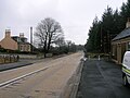
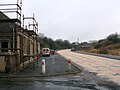
Views of Barkip in 2011[edit]

Looking north.
Looking towards Beith.
Looking towards Dalry.

Remnants of Brackenhills station.


The Den[edit]
|
External links[edit]
- Video and commentary on Barkip / 'The Den'.
- Video and commentary on the old Kersland Barony School and Church at Barkip
- Video and commentary on the area surrounding Barkip / 'The Den'.
- The Little Barkip Biogas Powerstation.